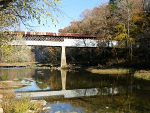
Locust Fork below Swann Bridge
By Todd Keith
When the opportunity to tag along with Dr. Jim Lacefield, a geologist and author of Lost Worlds in Alabama Rocks: A Guide; conservation photographer Beth Young and environmentalist James Lowery of UAB, to learn more about the Black Warrior Watershed, I wasn’t going to let it pass by. Specifically, we were headed for Cornelius Beach and Powell Falls on the Locust Fork, not too far downstream from Swann Bridge.
Flowing freely through Etowah, Marshall, and Blount Counties to form the Black Warrior River in northwest Jefferson County, the Locust Fork river is listed in the top 2% of the nation’s rivers with “outstandingly remarkable” values. And given the large number of dams in the state that turn nearly all of our major rivers into impoundments and lakes (generating 7% of Alabama’s energy needs), protecting what remains seems an altogether important task. The Locust Fork is one of Alabama’s few remaining free-flowing rivers and a priceless treasure for the state

Swann Covered Bridge near Oneonta
The Black Warrior River and it’s many tributaries, the northern sister system to the treasured Cahaba River, embraces the north portion of Alabama’s largest city, Birmingham, including the Mulberry Fork and magnificent Locust Fork, then stretches north and west to include the Sipsey River and finally flows down past Tuscaloosa and on to Demopolis. The system starts in the Appalachian Mountains and ends in the coastal plain, flowing through a bewilderingly diverse landscape. It stretches 178 miles, but its total drainage area is 6,275 square miles, a hefty portion of north central Alabama. Along with the Cahaba River, the Black Warrior can rightly be called Alabama’s heart river, central to the state both in its geographical course as well as in the number of biological treasured contained within.
Curiously, the Locust Fork is older than the mountains it flows through, actually cutting across and through at least 13 ridges in its course. These “water gaps” as they are called show that there was a river here when the Appalachian Mountains were being lifted—probably not the actual Locust Fork itself, but another older river course that the present day Locust Fork follows, explains Dr. Jim Lacefield. “No one has even named the old coal age river, call it the “Ancestral Locust Fork,” Lacefield says. “This was a big river, about the size of the Mississippi River up near Cairo, Illinois. The evidence is how much sand was moved downriver in that time. The real secrets are in the rock.”

Powell Falls on the Locust Fork of the Black Warrior River
One of the nicer aspects of taking a day off to look at the Black Warrior River Watershed—specifically Locust Fork at Cornelius Beach and Powell Falls below Swann Covered Bridge—is that you begin to realize there are thousands of proverbial “wells,” from scenic little spots that few have heard of to newly recognized treasures like Hurricane Creek. You see the lower Black Warrior River, a waterway that does the unglamorous work that Alabamians require of it, transporting industrial goods like coal, chemicals, coke wood, and steel up and down the length of our state to ports, cities and countries beyond. You see the unparallel beauty of the Locus Fork, a pristine stretch to cherish. You see a great variety within one watershed that means so many things to so many different people in Alabama.
Heck, a quick look on a map of the river system and you realize just how many creeks, streams and other waterways make up the whole… Black Warrior River, Sipsey Fork, Mulberry Fork, Locust Fork, Hurricane Creek, Smith Lake, Turkey Creek, Village Creek, North River, Dry Creek, Duck River, Inland Lake, Five Mile Creek, Highland Lake, Valley Creek…
As of yet, you do not, except among the few who deeply study the system, see a greater consciousness among the public that says this is a treasure to protect for generations. That’s going to have to change if this treasure is going to remain.

